1.1
Description of the Project
1.1.1
The Hongkong Electric Company Limited
(HEC) is responsible for the generation and supply of electricity to Hong Kong
and Lamma Island. At present, all
electric power is generated from Lamma Power Station (LPS) which is located on
Lamma Island. LPS, with a total
installed capacity of 3,420MW, comprises 2,500MW coal-fired units for base load
operation and 920MW gas turbine units for peak lopping operation. The annual coal consumption in 2001 is about
four million tons.
1.1.2
A coal jetty designed for 100,000 DWT
coal vessels and a dedicated Navigation Channel (the Channel) have been in
operation since the early 1980's to facilitate delivery of coal from overseas
to LPS by ocean going vessels. To
ensure an adequate underkeel clearance for safe operation of coal vessels
involved, maintenance dredging was carried out at the Channel in 1989/90 to
bring the seabed level to - 16.5mPD.
Again, due to natural siltation, the water depth at the Channel has now
been reduced to about - 14mPD which is close to the limit for safe navigation
of coal vessels of Panamax size (about 65,000 DWT) which is the smallest class
of ocean going coal vessel in the market.
1.1.3
Even with the first new 300MW
gas-fired unit in service at Lamma Power Station Extension, the coal-fired
units of LPS still have to operate to meet the majority of the electricity
demand. The annual coal consumption is
around four million tons.
1.1.4
As the siltation is building up and in
view of the importance to have in place a safe navigation channel with adequate
water depth for ocean going coal vessels, maintenance dredging must be carried
out in 2003. Otherwise, coal supply to
the LPS will be seriously hampered and the reliability of electricity supply
will be jeopardized. The proposed
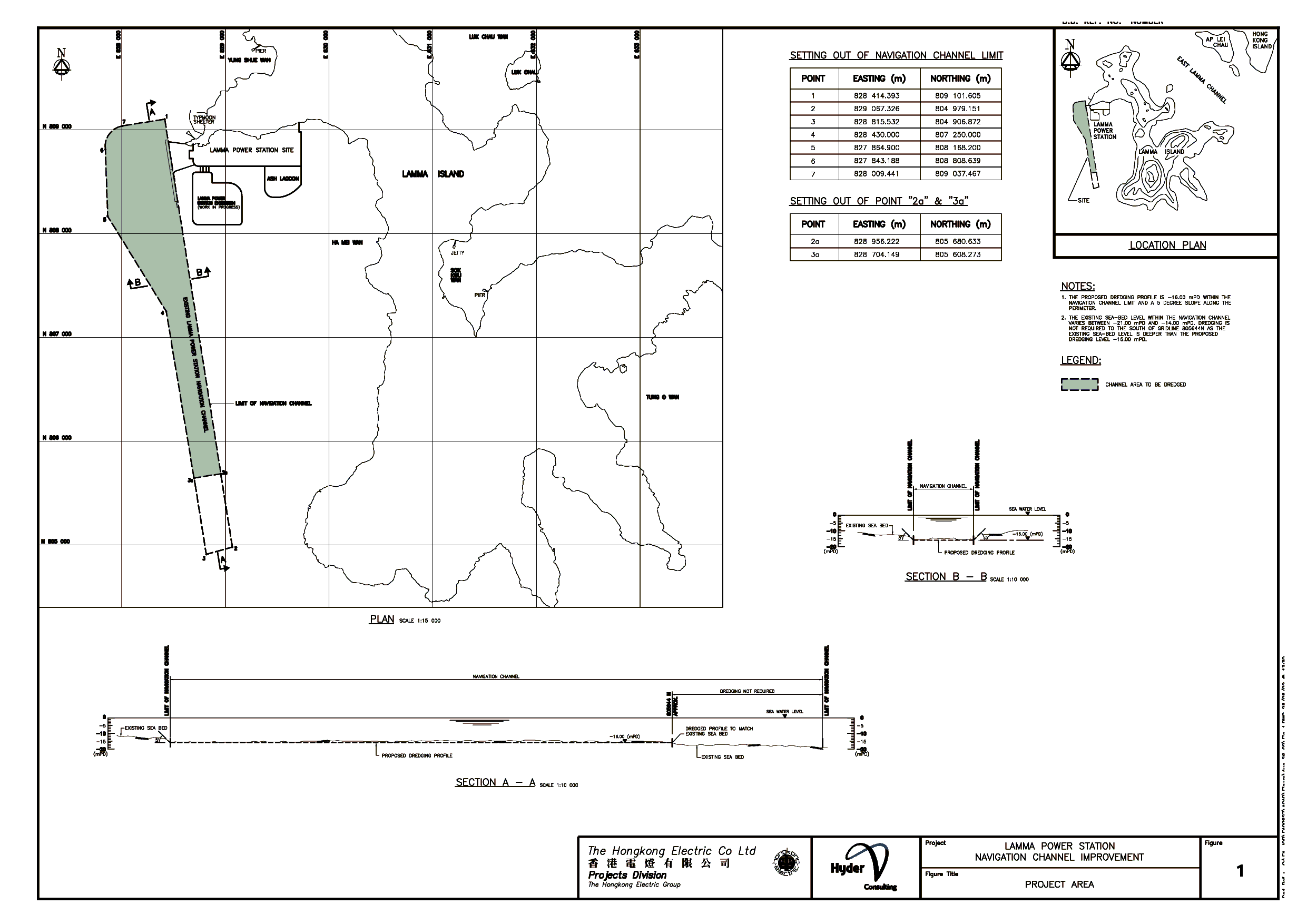
maintenance dredging work involves deepening the existing Channel to - 16mPD
with an estimated total dredging volume of 2.98 million m3. The
proposed Project Area and the dredging profile are illustrated in Figure 1.
1.1.5
The proposed dredging operation is
scheduled to take place between May 2003 and December 2003 on a 24-hour basis.
Marine vessels will transport the dredged sediment to the Government approved
disposal sites at East Ninepin, East Tung Lung Chau and East Sha Chau.
1.1.6
As
the total dredging volume exceeds 500,000m3, the dredging operation of the Channel improvement is a designated
project according to the Environmental Impact Assessment (EIA) Ordinance,
Schedule 2, Part I, C.12. A Project
Profile was submitted by HEC to EPD on 11 June 2001 for application of an EIA
Study Brief, which (Brief No. ESB-078/2001) was issued by EPD on 23 July
2001. Hyder Consulting Ltd was
commissioned by HEC to undertake the EIA Study in accordance with the EIA Study
Brief.
1.1.7
The assessment undertaken and major
findings, conclusions and recommendations of this EIA are summarised in this
document.
1.2
Study Objectives
1.2.1
The objectives of the EIA Study are as
follows:
(a)
To describe the proposed Project and
associated works together with the requirements for carrying out the proposed
Project;
(b)
To consider alternative method(s) for
the dredging work and design to ensure safe delivery of fuel to the power station;
and to compare the environmental benefits and dis-benefits of each of the
method(s) and design in selecting a preferred one;
(c)
To identify and describe elements of
the community and environment likely to be affected by the proposed Project
and/or likely to cause adverse impacts to the proposed Project, including
natural and man-made environment;
(d)
To propose the provision of
infrastructure or mitigation measures so as to minimize pollution, environmental
disturbance and nuisance during construction of the proposed Project;
(e)
To identify, predict and evaluate the
residual (i.e. after practicable mitigation) environmental impacts and the
cumulative effects expected to arise during the construction and operation
phases of the proposed Project in relation to the sensitive receivers (SRs) and
potential affected uses;
(f)
To identify, assess and specify
methods, measures and standards, to be included in the detailed design and construction
and operation of the proposed Project which are necessary to mitigate these
environmental impacts and reducing them to acceptable levels;
(g)
To investigate the extent of the
secondary environmental impacts that may arise from the proposed mitigation
measures, and to identify the constraints associated with the mitigation
measures recommended in the EIA Study as well as provision of any necessary
modification;
(h)
To identify, within the Study Area, any
individual project(s) that fall under Schedule 2 of the EIA Ordinance (EIAO);
to ascertain whether the findings of this EIA Study have adequately addressed
the environmental impacts of those projects; and where necessary to identify
the outstanding issues that need to be addressed in any further detailed EIA
Study; and
(i)
To design and specify environmental
monitoring and audit (EM&A) requirements, if required, to ensure the
implementation and the effectiveness of the environmental protection and
pollution control measures adopted.
2.1
Dredging Options
2.1.1
The major potential cause of
environmental impact for this Project is the associated dredging works during
the construction stage. The potential environmental
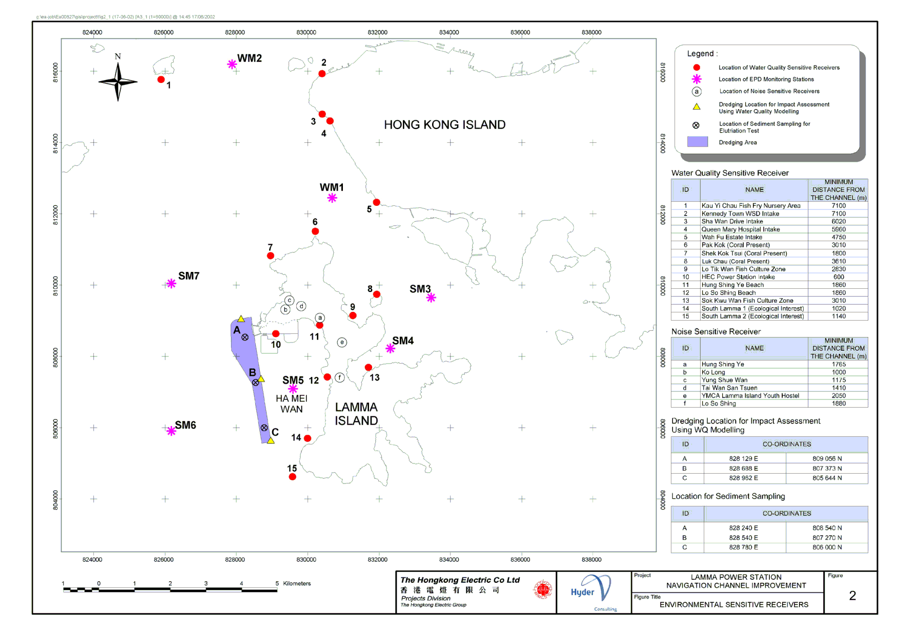
SRs of the dredging works have been identified and are illustrated in Figure 2.
2.1.2
Two dredging options have been
considered. They are grab dredgers with
cage-type silt curtains and trailer suction hopper dredgers (TSHD).
2.1.3
For
the TSHD option, it was assumed that there would be only one TSHD to be deployed for the dredging works, operating intermittently at a
dredging cycle of 30 minute dredging and 2 hour travelling between the dredging
site and the allocated dumping site.
2.1.4
For the grab dredger options, it was
assumed that the dredging would be carried out continuously with the dumping of
the dredged material being handled by barges and tugboats. The number of grab dredgers operating at any
one time will depend on the maximum dredging rates allowed, but will not be
more than 5 and the grab capacity will not be less than 8 m3.
2.1.5
Based on the sediment quality review
conducted as part of this EIA Study, the sediment to be dredged is of low contaminant
levels hence will not cause any unacceptable water quality impacts at the
disposal sites allocated by the Government.
No further impact assessment has therefore been carried out under this
Study for the disposal of the dredged material.
2.2
Water Quality
2.2.1
The potential water quality (WQ)
impact of the proposed dredging works has been assessed using the Lamma Channel
Model constructed from a previous EIA study for the Lamma Power Station
Extension.
2.2.2
The yearly tidal conditions were represented
by a 15-day spring to neap tidal cycle each in the dry and wet season
respectively.
2.2.3
The Channel to be dredged is divided
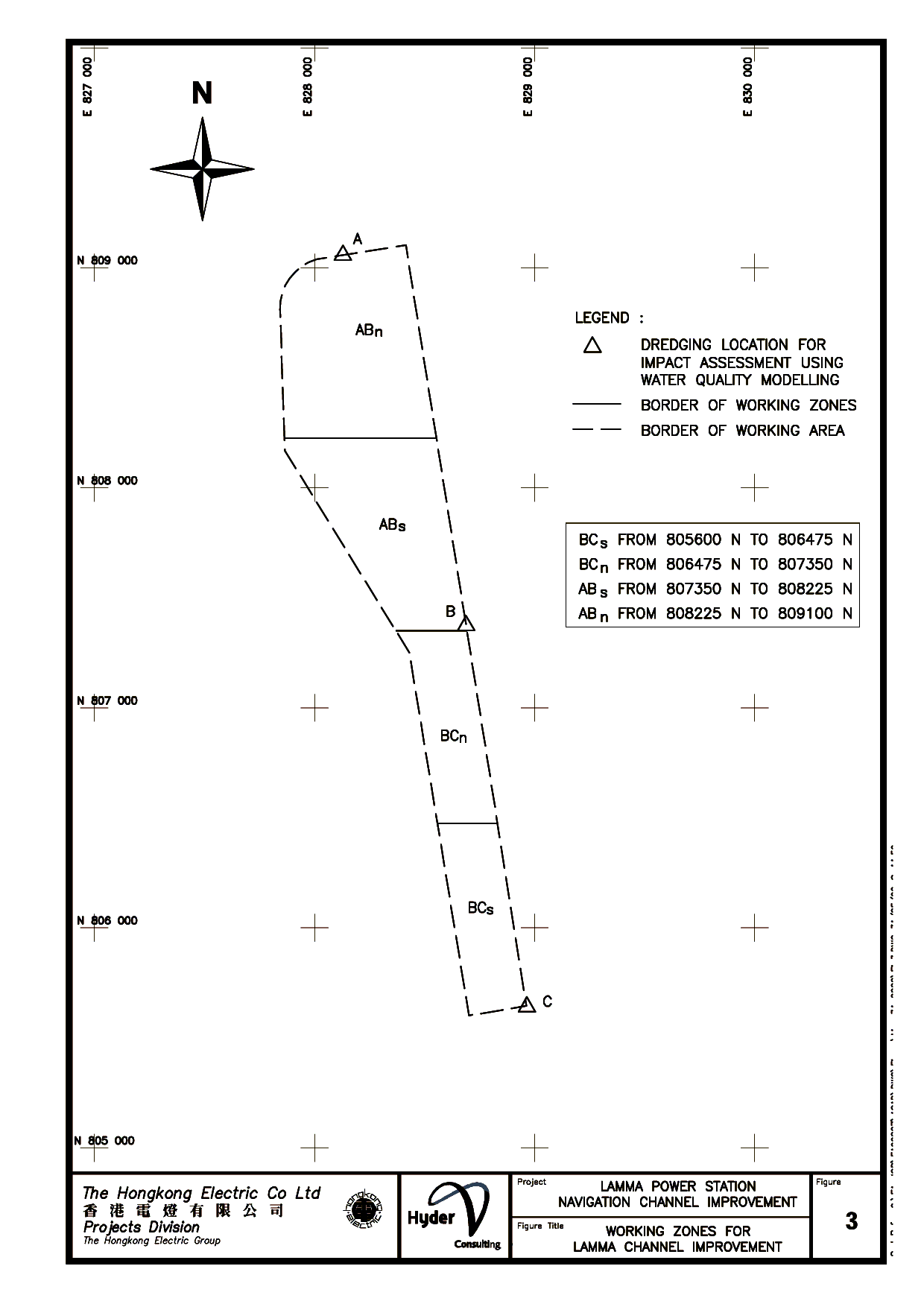
equally in terms of the Northing Coordinates into four working zones: ABn, ABs,
BCn and BCs as shown in Figure 3. While
the location of dredging will be moving all the time within the Channel, the
most adverse impact of the whole dredging operation can be represented by
dredging at either Dredging Location A, B or C as shown in Figure 3.
2.2.4
The impact of dredging at Location A
would represent the worst scenario for the water quality SRs (WQSRs) to the
north of the Channel such as those in the Western Buffer Water Control Zone
(WCZ). The dredging at Location C would represent the worst-case scenario for
the WQSRs to the south of the Channel such as the south Lamma water. Location C represents the most southern
point where the dredging will take place. According to the latest bathymetric
survey of the Channel, there is already sufficient water depth and no dredging
will be required in the southern part of the Channel beyond Location C. The
other adverse scenarios which may not be covered by dredging at Locations A and
C can be accounted for by the dredging at Location B.
2.2.5
As different dredging contractors may be
equipped with different dredgers, HEC would like to have the flexibility of
appointing the most suitable contractors for carrying out the proposed dredging
works in the future. To this end, the maximum dredging rates which would ensure
no unacceptable environmental impacts, have been estimated.
2.2.6
The maximum dredging rates were first
estimated such that the SS elevation at the WQSRs resulting from the dredging
at Locations A, B or C would not lead to an unacceptable level. Assessments were then carried out for the
estimated maximum dredging rates to ensure no unacceptable WQ impacts in terms
of the other WQ parameters.
2.2.7
Sediment samples have been collected
at representative locations in the Channel and elutriation tests have been
carried out on the samples to determine the releasing potential of various
contaminants from the sediment into the receiving water during dredging. The tested parameters included heavy metals,
nutrients, sediment oxygen demand and micro-pollutants (e.g. Poly Chlorinated
Biphenyls (PCBs), chlorinated pesticides, Tributyl Tin (TBT), Poly Aromatic
Hydrocarbons (PAHs), etc).
2.2.8
The elutriation test results were then
used to assess the potential elevation of the pollution levels in terms of those
pollutants at the WQSRs during the dredging operations at the estimated
dredging rates.
2.2.9
The contents of all heavy metals and
organic micro-pollutants were found to be below the detection limits. It was therefore concluded that the proposed
dredging works would not result in unacceptable environmental effects in terms
of the potential release of heavy metals and the organic micro-pollutants.
2.2.10 The proposed dredging would result in some depletion of dissolved
oxygen in the WQSRs, but the effect was predicted to be within the acceptable
level.
2.2.11 The ammoniacal nitrogen level resulting from the dredging works was
found to be negligible. The baseline
total inorganic nitrogen level in the WQSRs already exceeds the threshold value
of the Water Quality Objectives (WQOs).
2.2.12 Under the maximum dredging rates estimated, the predicted deposition
rates were less than 0.01 kg/m2/day along the western coast of Lamma
Island and less than 0.001 kg/m2/day in the south Lamma waters for
all dredging scenarios, below the level of any ecological concern.
2.2.13 The cumulative effects of other concurrent dredging/disposal
activities on the WQSRs of this Project were found to be minimal.
2.3
Recommended Maximum Dredging Rates and Proposed Works Schedule
2.3.1
The estimated maximum dredging rates,
less 10% to allow for contingency and the cumulative effects from other
concurrent projects, have been recommended as the maximum daily dredging rates. Based on the maximum dredging rates for
dredging at Dredging Locations A, B or C, the maximum dredging rates for
dredging at the individual working zones have been conservatively estimated as
in Table 1. The recommended maximum dredging rate for a working zone is the
total dredging rates at any one time, assuming all dredging activities take
place within that working zone.
Table 1 Recommended Maximum Dredging Rates
|
Season
|
Wet
Season (m3/day)
(April – September)
|
Dry
Season (m3/day)
(October – March)
|
|
Working
Zone
|
ABn
|
ABs
|
BCn
|
BCs
|
ABn
|
ABs
|
BCn
|
BCs
|
|
Grab Dredger
with Cage-Type Silt Curtains (Grab Capacity ³ 8 m3)
|
m3/day
|
33,800
|
31,400
|
26,300
|
21,200
|
43,800
|
33,200
|
33,200
|
34,200
|
|
m3/hr
|
1,549
|
1,439
|
1,205
|
972
|
2,008
|
1,522
|
1,522
|
1,568
|
|
TSHD
|
m3/day
|
12,500
|
11,300
|
8,300
|
5,300
|
39,500
|
34,300
|
27,000
|
19,700
|
|
m3/cycle
|
1,432
|
1,295
|
951
|
607
|
4,526
|
3,930
|
3,094
|
2,257
|
Note: The maximum daily
dredging rates are based on 24-hour operations. If the daily working hours are
restricted, the maximum daily dredging rates should be reduced proportionally.
2.3.2
For the grab dredger option, dredging
may be carried out concurrently at more than one working zones during some time
periods. In this case, the combined
dredging rates during those time periods should not exceed the lowest of the
maximum rates recommended for the concerned working zones. Take the grab dredger option in the wet
season for example. If the dredging
work is carried out at ABn, ABs and BCn concurrently, the combined maximum
dredging rate should not exceed 26,300 m3/d. For the TSHD option, there will be only
one TSHD working in the Channel during the works period.
2.3.3
All dredging at the dredging location
A, B or C at the estimated maximum dredging rates represent the worst-case
scenarios in terms of the potential environmental impacts. As long as the dredging rates do not exceed
the above recommended maximum dredging rates for the respective working zones,
the proposed Channel Improvement works would not lead to WQ non-compliance with
the WQOs in any of the WQSRs throughout the dredging period.
2.4
Marine Ecology
2.4.1
Literature and studies on the marine
and coastal ecology of the Study Area has been reviewed in detail for this EIA
and supplemented with additional coral dive field survey where considered
necessary.
2.4.2
The coastal stretches and waters off
southern to south-western Lamma are of an important ecological value. Coastal areas here have SSSI status and have
been proposed for consideration as a Marine Park. Southern Lamma’s coastal
waters support hard and soft corals, Finless Porpoises, nesting sites for Green
Turtles and a more diverse and abundant benthic infauna and exposed soft shore
communities.
2.4.3
The Finless Porpoises were considered
to be the key species potentially affected both directly and indirectly by
works given that the southern extent of the Study Area is considered to be an
important habitat of the porpoises, particularly in the winter/spring months.
2.4.4
The areas around the Lamma Power
Station and immediately to the south have been disturbed frequently, comprise
fine sediments and generally support less diverse benthic and intertidal
communities. The Finless Porpoises and
Chinese White Dolphins are found only infrequently in these waters. Corals in this area are extremely sparse and
patchy and already showing signs of stress. Furthermore they did not support
significant reef communities and are of low ecological value when put into the
Hong Kong context. When compared to
other sites on Lamma, the eastern coast (Tung O Wan) and southern coast (Sham
Wan) support more extensive and significant coral communities.
2.4.5
WQ modelling has indicated that the
potential WQ impact of the proposed dredging works would be small and would not
lead to the exceedance of the WQOs at the SRs.
The highest SS elevation would be in the immediate vicinity of the works
area, which will likely be avoided temporarily by mobile organisms such as fish
and cetaceans. Increases in SS
concentrations and sedimentation rates have been predicted to be sufficiently
low so as not to result in harmful effects on remaining patches of the corals
along the west coast. Indirect impacts
on the Finless Porpoises and their prey are expected to be minimal. The Green Turtle nesting site at Sham Wan
and the sensitive coral sites at the east and south coast of Lamma will not be
affected by this Project.
2.5
Fisheries
2.5.1
Waters around West Lamma are
relatively important fishing grounds with the exception of Pak Kok which has a
fairly low ranking in Hong Kong in terms of value and production. Po Law Tsui contains the most valuable
fishing grounds off western Lamma in terms of production per hectare. These fishing grounds encompass the waters
around the Lamma Power Station. Of the
species most commonly caught in the Study Area, Pseudosciaena crocea and Oratosquilla spp are high
value species. The remainder are
commonly regarded as trash species that are generally sold as fish feed to
mariculturalists.
2.5.2
Short-term impacts on fisheries could potentially
arise as a result of sediment releases associated with dredging. As elevations in SS levels would not lead to
non-compliance with the WQOs, the potential impact is unlikely to be
significant.
2.6
Construction Noise
2.6.1
No operational noise impact is anticipated
from this Project. Powered Mechanical
Equipment (PME) will be the primary source of construction noise. The noise
impact on the noise SRs (NSRs) of this Project has been assessed based on the
estimation of the provisional plant inventory and the proposed working
schedule. The construction noise impact
during the normal working hours has been found to be negligible and the
cumulative noise levels at the NSRs after taking into account the other
concurrent projects are well below the noise limits set by EIAO Technical
Memorandum (EIA-TM).
2.6.2
It is planned that the dredging
operation will be on a 24-hour basis and a Construction Noise Permit is
required during the restricted hours. It
is predicted that the noise impact of this Project will comply with the noise
criteria for issuing a Construction Noise Permit.
2.7
Waste Management
2.7.1
The dredged marine sediment is the
only waste source generated from the proposed Channel Improvement works. Based
on the recent data collected in and around the Channel the marine sediment has
been classified as Category L and is suitable for open sea disposal. The
disposal sites at East Tung Lung Chau,
East Ninepin and East Sha Chau have provisionally been allocated by the
Marine Fill Committee (MFC) for the Channel Improvement works.
2.8
Operational Impacts
2.8.1
The potential operational impact is
the changes in the local hydrodynamic regime arising from restoring the Channel
water depth to its design level, which could lead to changes in the local WQ
and the local sediment transport regime.
2.8.2
The effect on the local hydrodynamic
regime was concluded to be minimal and the impact on the local WQ conditions
and the local sediment transport regime is negligible.
3.1
Mitigation Measures
For Both Grab Dredger and TSHD Options
3.1.1
The dredging rate should not exceed
the recommended maximum dredging rates for respective working zones, dredging options
and seasons.
3.1.2
Should the WQ monitoring during the
construction stage indicate any exceedance of the WQOs due to this Project, the
dredging rate should be further reduced.
3.1.3
To minimise impacts to sensitive species
in the waters around southern Lamma, all vessel movements to disposal grounds
will bypass the Finless Porpoise habitat area and be subject to a maximum speed
limit of 10 knots in south Lamma
waters.
3.1.4
The southern-most sections (Working
Zone BCs) will not be dredged during the most critical period of the Finless
Porpoise calving season i.e. February to April.
3.1.5
If dredging work
is carried out in more than one working zones in any day, the lowest maximum
rate in
the affected zones should apply for that day.
3.1.6
The number of dredgers and operation
conditions specified in the applicable CNPs should be strictly followed.
For Grab Dredger Option Only
3.1.7
The total number of grab dredgers
deployed concurrently for the proposed dredging works should not be more than
5.
3.1.8
Cage-type silt curtains should be used
for the grab dredger options, the grab capacity should not be less than 8 m3
and the silt curtains should be extended to the seabed level as far as
possible.
For TSHD Option Only
3.1.9
There should not be more than one TSHD
to be deployed concurrently for the proposed dredging works.
1.1
3.2
Good Site Practice
3.2.1
In order to further minimize the
potential WQ impact, the following good site practice, which is applicable to both
dredging options, is recommended:
·
Although
the maximum dredging rates are in terms of the dredging volume per day, the
daily dredging volume should be spread as evenly as possible over the 24 hour
period whenever practical to avoid sudden surge of pollution elevation during short spells, in particular when
dredging at the recommended maximum rates;
·
Special care should be taken during
lowering and lifting grabs to minimize unnecessary disturbance to the seabed;
·
Vessels used should have adequate clearance of the seabed in order to
reduce undue turbidity generated by turbulence from vessel movement or
propeller wash;
·
Barges should
be fitted with tight fitting seals to their bottom openings to prevent leakage
of material;
·
The contractor should ensure that grabs are tightly closed and
hoist speed is suitably low;
·
Barges should not be filled to a
level which will cause overflow of materials during loading and transportation;
·
Large objects should be removed from
the grab to avoid losses from partially closed
grabs; and
·
Appropriate monitoring of WQ during
dredging works should be undertaken to allow the implementation of appropriate
Action Plans to prevent any unacceptable WQ impacts.
3.2.2
In order to avoid potential impacts on
cetaceans, all vessel operators working on the Project should be thoroughly
briefed on:
·
the
possible presence of dolphins and porpoises in the vicinity of the Study Area
and along routes to the Project Area
·
rules
for safe vessel operation around cetaceans; and
·
slowing
to 10 knots in the presence of
cetaceans
·
the
dumping of chemicals, rubbish, oils etc into the water is strictly prohibited
and enforced.
4.1.1
A comprehensive Environmental
Monitoring and Audit (EM&A) programme for the construction phase has been
recommended. The EM&A requirements
cover WQ and waste management and are a full reflection of the recommendations
made from the EIA. No EM&A monitoring
work would be required during the operational phase as this Project has no
operation impact on the environment.
4.1.2
The dredging contractor is required to
maintain a daily log book to record the disposal volume of the dredged sediment
by every shipment. This information can
be used to audit the dredging rates. However,
real-time reporting of the monitoring data is considered to be unnecessary.
4.1.3
With the inclusion of the recommended
EM&A requirements into the works programme, it is anticipated that the
works can be carried out with full compliance of the requirements set by the
EIA-TM.
5.1.1
The proposed maintenance dredging in
the Channel would comply with all environmental standards and legislations,
provided that the recommended maximum dredging rates for the respective dredging
options are not exceeded and the proper mitigation measures and good site
practice recommended in this EIA are fully implemented.
